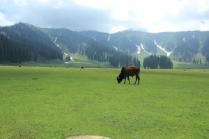
Bangus Valley
One of the relatively unknown areas of Kashmir with vast tourism potential is the valley of Bangus. Lying within the Trans-Himalayan areaBangus is a unique ecological combination comprising a mountain biome, which includes grassland biome with flora at lower altitudes; and Taiga or Coniferous forest. The valley which lies at an altitude of around 10,000 ft. above sea level is in the northern part of district Kupwara within the Handwara sub District. Occupying an estimated area of 300 sq.kms (20x15km) the principal valley locally known as Bodh Bangus (Big Bangus) consists of a linear elliptical bowl aligned along the east-west axis. The valley is surrounded by Rajwar and Mawar in the east, Shamasbury and Dajlungun Mountains in the west and Chowkibal and Karnah Guli in the north. A smaller valley known as Lokut Bangus (Small Bangus) lies on the north-eastern side of the main valley. Both the valleys have level green meadows surrounded by low-lying mountains covered with dense Coniferous forests (budloo) and a stream flowing through them.